By Kerry M
Back in early May, the 4WD Association forwarded to all clubs a request for assistance. Two people were intending to walk the Madigan Line in the northern Simpson Desert to raise funds and awareness for the Heart Research Foundation. They were looking for 2-3 vehicles to be their support crew. All food and fuel would be paid for in return for carting their supplies.
This seemed like an ideal incentive to travel this area of the Simpson Desert as we had already been through other areas and had visited Poeppel’s Corner 4 times.
After meeting with Rob, we decided that we “were in” even though it would be a slow trip, as they expected to walk 30-35 kms per day. Greg and Alan joined us; we were advised to plan for 24 days but take enough supplies for 30 days. Rob took us to meet his previous support team leader, Peter, and we were given suggestions on likely needs and minimum requirements. Water and fuel were the critical items. Peter also tracked down the trailer used on prior trips and assured us it was up to the task. It should be noted that the last trip was 17 years ago so memories become clouded with time.
Planning began and we based our fuel needs on 25ltr per 100 in the desert – so a minimum of 220ltrs per vehicle from Kulgera to Birdsville; this included fuel in tanks. Water was to be rationed at 5ltrs per person per day so 30 days x four people was 600 ltrs. The trekkers were to provide all their own supplies and take them in their vehicle.
We planned to leave on Thursday, 1 July, with Greg and Alan to meet us by Sunday at Old Andado Station. Greg was away on a club trip so he and Alan had to play catch up. Greg returned a day early so they were able to meet us on the Saturday evening at Old Andado.
Sunday: we awoke to a thermometer reading minus 2.4 and ice in the top of the water bottle – BRRRR. We explored the buildings which have been left as though someone had just walked out the door. The table was set, the pots were on the stove, the bed was made etc. There are flushing toilets and showers available (subject to rainfall and wood supply). The site is maintained by a 4WD club from Alice Springs. Later that morning we travelled to Camp 1A and set up for the night. Wal and Alan took the trekkers out to camp 1 but, despite doing laps, were not able to locate the actual marker. Alan is very confident that they drove over the spot but the marker had been removed. Six vehicles passed us, including a “tag-a-long” convoy.
Monday: We had agreed to meet the walkers at camp 5 so we drove on and sat to wait for them. They were to contact us each night and advise their location. They managed 17km on day 1 and 22 km on day 2. Then Rob called Wednesday morning to ask us to meet him about 10kms out and bring more water. The gibber rocks were much slower to walk on than he recalled so they chose to walk the last 10km to camp on the track. Wednesday evening it was decided that although it was further, they would walk on the track as it was easier. This also meant that they would only carry day’s packs, thus lessening their loads. A full pack was about 25-30kg whereas a day pack was 10-15kg. This also meant that we would not have to bury cache boxes but rather drive a set distance and camp for the night. A total of 8 vehicles passed over the three days at camp 5.
Thursday: another fresh morning with ice forming on the car after sunrise but it didn’t last very long. We began to come across some larger dunes (25mtr+) and, as we crested one, we were met by two men and six camels. The father and son were “just out walking” across the desert with their camels. Seems they have done this previously. What a way to really see the country. We drove 30km and set up camp. Passed marker 6 and camped at marker 7 today. Another 4 vehicles passed us today, including 1 going the wrong way.
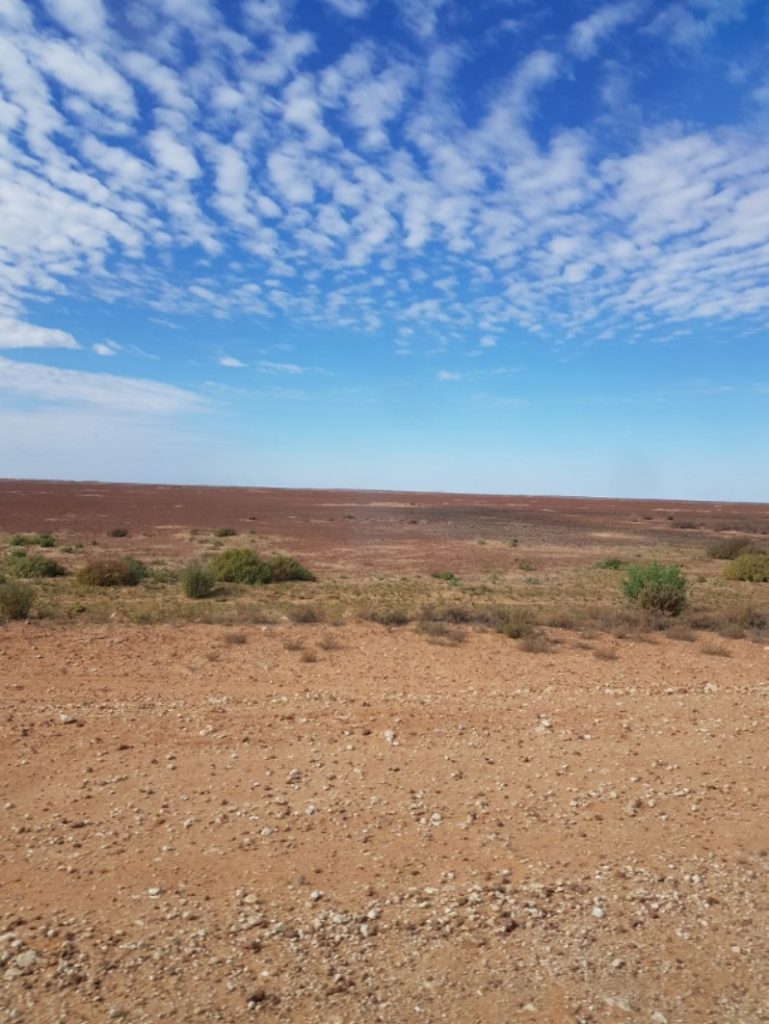
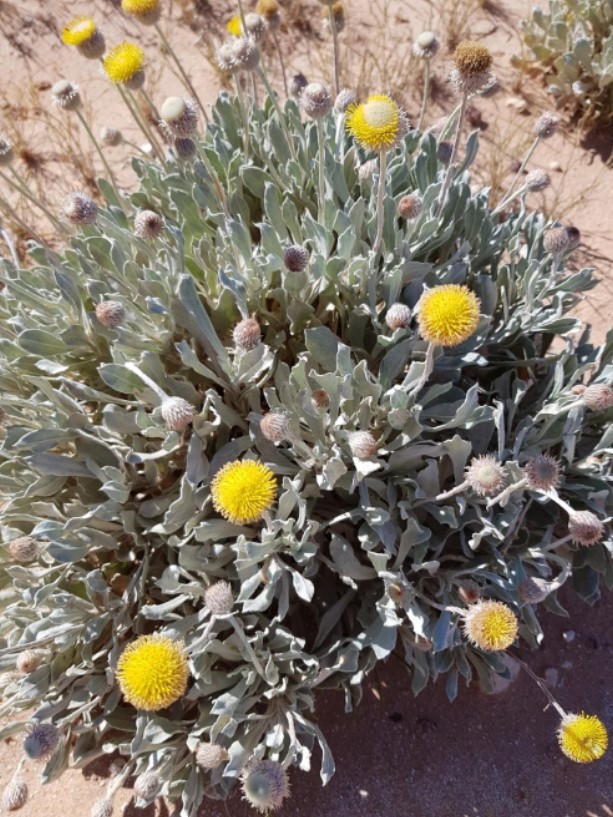
Friday: we had to set up camp amongst the spinifex as the 35km mark was between camps. Just as well we only had small tents as this left enough room to walk around without getting stabbed in the shins. It’s not called SPINIfex for no reason! There were places where the seed stems looked like wheat fields as the late rains had the desert in full growth. We didn’t see it at its best but there were still a few wildflowers blooming and the wattle was in flower. Passed marker 8. 3 vehicles passed us today.
Saturday: we came across 2 swales that had gidgee trees growing in them. These trees would become more frequent in the Eastern side of the desert. We camped at marker 9. 3 vehicles passed us today including 1 with ratchet straps holding the tailgate shut.
Sunday: the day it all went pear shaped. We were about an hour into our trip when Rob’s Nissan started to have clutch problems on the dunes. Sure enough, it didn’t take long and the clutch gave up 2/3 way up a dune. So, it was out with the shovels to dig the sand away from tyres and shape it so we could unhook the trailer and turn it 90 degrees. It was towed back to the swale and parked off the track.
After more digging Alan was able to get enough bite on the clutch to reverse back down the dune and off the track. Wal got underneath and decided that there was no adjustment left at all and the car wasn’t going anywhere. I then “pulled the pin” on the venture. Greg went to collect the walkers and inform Rob of his car’s problem. Rob had recovery insurance but needed his daughter in Adelaide to deal with the insurance company as you cannot call 1800 numbers from a sat phone. A truck was to be sent from Alice Springs and eventually collect Rob, Brigid and the car.
The highlight of the day was to be a visit from a wild bull camel late in the afternoon. He crested the dune that had caused us grief. Seemed to look and say, “What are you lot doing here?” and, after giving us a look over, he turned and ambled away. When Alan and Rob reached the top of the dune, hoping for more photos, he was nowhere to be seen. 3 cars passed us today. We stayed with the trekkers for 2 full days and, at their insistence, moved on Tuesday afternoon.
Tuesday: we left the trekkers and soon came upon their pickup point. Greg had marked the 220km point where he collected them from. We proceeded onto camps 10 & 11 and camped for the night.
Wednesday: Camp 12 had a visitors book. I managed to find a pencil to sign it with. There are signatures from all over the world. We then travelled on to the junction with the Hay River track which is a much easier drive, as it travels between the dunes and, at camp 16, which has the “blaze tree,” we turned east onto the remainder of the Madigan Line track. There were quite a few vehicles at camp 16 as it can easily be reached in a day from Birdsville. We camped that night at camp 17 which has some gidgee trees nearby.
Thursday saw us turn onto the “flood bypass track” and pass the rather unexpected Dickerrie waterhole which is one of three pools that hold water for quite a few years after the Eyre Creek floods. We spent some time at the Annadale Station ruins, inspecting what remains of the former home and stockyards that sit on the banks of Eyre Creek. We found the markers for camps 18, 19 & 20 and camped on the roadside for our last evening in the desert.
Friday: Not long after leaving camp, we came across a bull camel and his 6 cows. They had just been into the cattle trough and were quickly on their way when we came into view. We turned onto the QAA line and were met with a stream of traffic. Many were going out to Poeppel’s Corner; others were beginning their journey across the Simpson Desert. We instantly noticed the deterioration in the track, as it was quite chewed up on the eastern side of the dunes (our down sided but upside when heading away from town). Four groups pulled over to let us through as there was only 2 of us. Not long after cresting a dune at 28 mtrs, we pulled over to let a convoy of 8 through. It was while we were out stretching our legs, we realised we had lost a gas bottle and the spare trye!! The constant bouncing had sawed through the rachet straps and the goods had bounced off, unnoticed, in the dust.
We soon arrived at Big Red and had no trouble crossing it. We stopped on the other side to air up and watch the dust blow across the Big Red Bash campground. The road soon turned to bitumen which was a bit disappointing, but we arrived at the Police station to be informed we needed to go to the information centre and complete our QLD entry form and show it to him, and then a SA returning resident form for return to home. A very welcome hot shower and a meal at the pub saw our trip come to a close.
Saturday: Alan and Greg left us to head for home. Wal and I stayed for another day.
Sunday: the need to travel at 60kph (no trailer spare) saw us arrive at the Warburton Crossing for the evening. The creek is still flowing but the crossing now has a rocky base. We met 3 cars from Victoria, raising awareness of Motor Neurone Disease. They had just come down the Warburton Track and were heading into Birdsville. One of the cars was a late model Porsche.
Monday: on our way down the track we passed the remains of a burnt out caravan and quite a few tyres and rims. We camped by the roadside near Farina.
Tuesday: we had every intention of ambling home and staying another night on the road but the news came through that SA was going into lockdown at 6 pm so we made a dash for home, arriving at 4.30 pm.
Diesel costs: Pt Augusta $143.9; Coober Pedy $155.9 ; Kulgera $189.9; Finke $196.9
Diesel use:
– Up to Finke towing a fully laden trailer 18.65lt/100 or 5.36km/ltr
– Through the desert, mostly with the trailer on 22.77lt/100 or 4.39 km/ltr
– The Birdsville track at 60kmh with empty trailer 16.9 ltr/100 or 5.91 km/ltr
Total distance: 3417.6km
Total fuel: 653.86 ltrs
Average: 19.15 ltr/100 or 5.22 km/ltr
